GEM Atlas 2.0
Ground-shaking intensities at multiple return periods all over the world.
Atlas 2.0 is GEM’s new hazard data service that allows users to access and interact with the outputs from the GEM Global Mosaic, used to generate the Global Seismic Hazard Maps. Available for public-good and commercial applications, users can now access full sets of hazard curves that describe the intensity of ground-shaking for different soil conditions, at multiple return periods, all over the world.

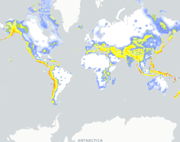
Global Seismic Hazard Map All Curves v2023.2
The Global Earthquake Model (GEM) Global Seismic Hazard Map (version 2023.2).
Sponsors
GEM is comprised of collaborators from public, private, academic and non-government organizations worldwide. These partners work together to advance the state-of-the-art for disaster risk reduction by developing data, tools and information and conducting hazard and risk assessments for improving our understanding of earthquake hazard and risk globally. To learn more about our sponsors, partners and collaborators, please visit the GEM Partners page.